
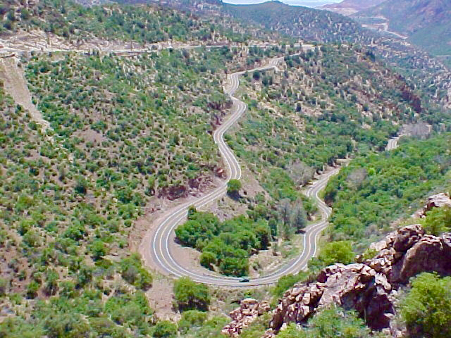
Devil's Highway, Eastern Arizona
Length: Morenci to Springerville on US Highway 191; 116.7 miles one way or 2:57 non-stop one way
Directions: Morenci is 173.6 miles east of Tucson or 2:45 minutes on I-10 East to exit 352 – Highway 191 north.
What makes it memorable? Approximates the route of Coronado between 1540 and 1542. Was initially named Highway 666 as it was attached to the parent highway US 66. It is a bucket list drive of curves. There is initially a scenic view of Morenci Mine. Higher up views of the mountain ridges of SE Arizona abound. Mile 192 there is a wide grassy plateau of easy-open driving; restful after the abundant curves. Before milepost 225 there is the Blue Vista overlook of the Mogollon Rim at 9,184’. Hannagan Meadows is beautifully followed by long sweeping curves around milepost 247.
Other Helpful Comments: Take care around Morenci as the mining trucks have the right of way. You must also pay attention to the fact that virtually the entire route is without shoulders. At higher elevations in forested areas watch out for elk.
Sportsman’s Lodge in Alpine is a good stop for an overnight after 90+ miles of twisties. Phone number: (877)-560-7626
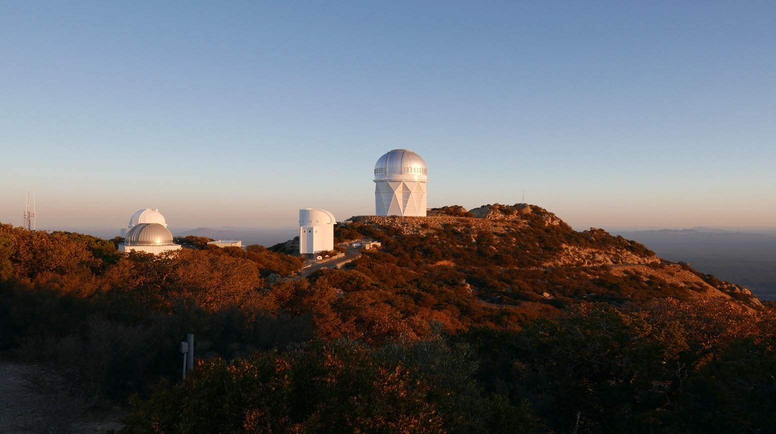
Kitt Peak
Length: 12 miles one way from the entry of State Route 386 off State Route 86.
Directions: Follow Ajo Highway west from Tucson, (State Route 86), for 37 miles to State Route 386. Turn left, (or south), and follow the signs for 12 miles to Kitt Peak National Observatory.
What makes it memorable? The view from the observatory area in any direction is vast and awe-inspiring. The lower sections of the road feature broad plains of Teddy Bear Cholla and other remarkable desert flora. At mile 8.4 a bend in the road offers incredible views to the west. Sheer rock walls frame excellent curves to test your suspension performance. The peak, at 6,875’ altitude offers a cool respite for a tree-shaded picnic.
Other Helpful Comments: If it is desired to incorporate a tour of the observatory then call Kitt Peak National Observatory, (520)-318-8726 or online noao.edu/kpno (This field could also include suggestions on places to eat, fuel stops or lack thereof, etc.)
Northern AZ & Southern Utah

Length: 17:36 and 1,102.1 miles
Tucson to Vermillion Cliffs National Monument is 408.0 miles and 6:09. The tour itself from the start at Vermillion Cliffs to the termination in Sedona is 8:00 and 465.2 miles. The return trip from Sedona to Tucson is 3:27 and 228.9 miles.
Directions: From Vermillion Cliffs to Marble Canyon travel 0:27 and 27.4 miles on US 89A south. From Marble Canyon to Red Canyon, Utah travel 2:30 and 140.2 miles via US 89A north and US 89 north. From Red Canyon, Utah to Antelope Pass travel 2:36 and 157.2 miles on US 89 south. From Antelope Pass to Sedona travel 2:27 and 140.4 miles on US 89 south.
Tucson to Vermillion Cliffs you will travel I-10 west, I-17 north, and US 89 north. From Sedona home to Tucson you will travel I-17 south and I-10 east. (times and mileage are indicated above)
What makes it memorable? This tour features some of the most scenic “red rock” country in the southwest. The Vermillion Cliffs National Monument features a great escarpment with a brilliantly colored stone. Nearby Marble Canyon has excellent views of beautiful rock formations carved by the Colorado River. This can be further enjoyed by viewing the canyon from the steel span of the Navajo Bridge, (actually two bridges: one for vehicles and the other for pedestrians). Not a mile from here is an interesting site for Native American architecture: The Cliff Dwellers Stone Houses. Red Canyon, Utah in the Dixie National Forest is Bryce’s lesser-known neighbor; similar magnificent scenery without the crowds. Antelope Pass features incredible views from its 6,151’ height and access to the photographer’s paradise of Antelope Canyon is easy. Finally, Sedona offers up great scenery, excellent accommodation, and cuisine.
Other Helpful Comments: Be vigilant going up the steep grade of Antelope pass for slower truck traffic.
Tonto Bridge Stage Park
Length: 3:15 minutes or 203 miles each way from Tucson
Directions: I-10 west to AZ 101 Loop North to AZ 87 N near Mesa. Take AZ 202 Loop East then continue on AZ 87 North to National Forest 583A in Gila County to Tonto State Park.
What makes it memorable? Highway 87 is bounded by open desert and broad vistas of the mountains east of Phoenix.
There are several scenic trails with interesting water features. There is the Pine Creek Trail and access to a waterfall. There is also a small rivulet that flows through a meadow and then suddenly drops 180’ to a creek below. The boulders at the bottom are covered with lush moss and ferns and there are pools of clear water.
Other Helpful Comments: The lodge at the park can be reserved for group events.
Tonto Bridge State Park AZ - printable page
Very Large Array, Western New Mexico
Length: Tucson to the Very Large Array near Magdalena, NM is 5:43 and 334 miles each way.
Directions: I-10 east to US 191 north to AZ 78 east – about 2:26 or 160 miles. Continue on AZ 78 east for 34.7 miles or 46 minutes. Turn left onto US 180 west for 54 minutes or 45.6 miles then follow NM 12 east to US 60 east to Datil, a trip of 1:16 or 74.1 miles. Turn right onto US 60 east 14 minutes or 15.4 miles to NM 53 south for 4.1 miles or 6 minutes to the Very Large Array.
What makes it memorable? The Very Large Array is a spectacular engineering marvel that has featured in several Hollywood productions, the most memorable of which was Jody Foster’s 1997 film Contact.
It is composed of some 27 radio telescope antennae each one of which is 94’ high, 82’ in diameter, and weighs 235 tons. They are moved on tracks by huge crawler tractors to realize either wide-angle or detailed views of the heavens. The rail system itself is composed of 39 miles of track.
There is also an excellent museum on the property that has fascinating displays of various discoveries realized by radio astronomy.
Other Helpful Comments: Tours of the VLA can be arranged in advance by calling the gift shop at (575)-835-7410.
30 minutes from the VLA is the charming town of Magdalena, NM. The old school gym is home to the Astronomical Lyceum which displays many vintage optical telescopes. The exhibit is curated by John Briggs.
Can be combined with or regarded as a subset of the Western New Mexico itinerary.
VLA New Mexico - printable page
Pinal County Webb Road, Oracle AZ
Length: 24 miles one way from State Route 77 at Oracle to State Route 77 at Mammoth
Directions: Take AZ 77 (Oracle Road) north from Tucson through Catalina to Oracle. Turn right on West American Avenue into Oracle. Follow West American Avenue through Oracle to Mount Lemmon Highway (2.3 miles). Turn right onto Mount Lemmon Highway and follow it for 3.2 miles to Webb Road. Turn left on Webb Road and follow it for 6.1 miles to South Veterans Memorial Boulevard. From here you can turn left to return to AZ77 or turn right to drive into San Manuel. If instead of turning left on Webb Road you stay on Mount Lemmon Highway for another 3.3 fun miles you’ll find yourself at the Arizona Zipline, which is another adventure.
What makes it memorable? Webb Road is a delightful little drive with many dips and turns. Along the way, you’ll see lots of beautiful desert scenery. It’s so much fun that you might decide to turn around drive it again in the other direction.
Other Helpful Comments:
As you drive through Oracle you’ll pass the Patio Café on the north side of American Avenue, about 2 miles from AZ77. This is an excellent place for breakfast if you are an early person, or lunch if you aren’t. You can sit outside on the back patio. If you decide to go to the Patio Café be patient, because their kitchen is small. It’s not fast food! Another alternative for a picnic is Oracle Park (not Oracle State Park) which is at the end of Evergreen Drive directly across American Avenue from the Patio Café. It’s a cute little park with several picnic tables and some nice shade trees.
Across the street from the Patio Café is the Oracle Inn, which is a great place for a cold beer on their patio. It may be closed in summer.
Watch your speed on AZ77 between Catalina and Oracle, and on American Avenue in Oracle. The limits are low and the enforcement is sometimes strict.
Western New Mexico
Length: 868.3 miles and 13:36
5 hours and 312.5 miles one way for the tour in New Mexico. Tucson to the beginning in Reserve, NM is 4:12 or 247.8 miles via I-10 east and US 191 north. From the termination in White Sands, NM home to Tucson is 308.0 miles and 4:24 on I-10.
Directions: This route will traverse Catron, Socorro, Lincoln and Otero counties of New Mexico. From Reserve travel 1:40 or 102.4 miles to Magdalena on NM 12 and US 60 east. From Magdalena travel 1:34 or 101.5 miles on US 60 east and US 380 east to Carrizozo. From Carrizozo travel on US 54 south to Alamogordo for 56 minutes or 57.8 miles. Enroute you will visit the 3 Rivers Petroglyph site. From Alamogordo travel US 70 west 49 minutes or 50.8 miles to White Sands.
What makes it memorable? The drive to Reserve on highway 191 is spectacular with great twisty sections and vistas of the Mogollon Rim and several mountain ranges. Reserve itself is steeped in the history of the Old West as the site of the gun battle between Elfego Baca and a gang of Texas cowboys. The route from there to the Very Large Array traverses an expansive plain and some amazing geologic landscapes, (for more about the Very Large Array of radio telescopes see the travel plan on this specific site). Between Carrizozo and Alamogordo you can see a large site of pre-historic rock art at the 3 Rivers Petroglyph site. In Alamogordo you can visit the Museum of Space History. White Sands National Monument features an otherworldly landscape of snow-white sand composed of gypsum crystals. You can drive about 8 miles into the monument.
Other Helpful Comments: If desired, the charming historic Spanish Colonial town of Mesilla, NM, south of Las Cruces, can be added. It features some terrific architecture along with great shops and eateries.